In my previous posts (part 1 and part 2), I described how ArcMap warns users that a coordinate transformation is required and some potential pitfalls to be aware of.
In this post, I will explain how to set a coordinate transformation in ArcMap.
How to Select a Coordinate Transformation
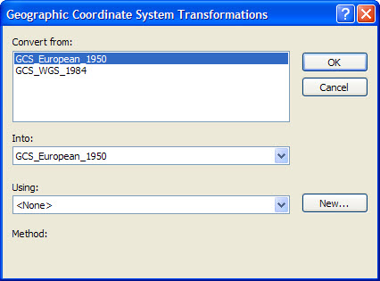
Open the Geographic Coordinate Systems Transformations dialog by either clicking on the Transformations button in the Geographic Coordinate Systems Warning dialog or in the Data Frame Properties dialog.
The Convert From list displays a list of geodetic datums on which the CRS properties of map layers are based, while the Convert Into dropdown displays the geodetic datum on which the CRS property of the data frame is based.
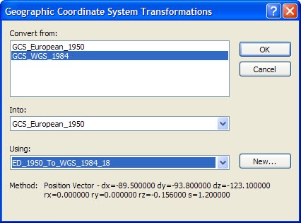
In the screenshot below, a coordinate transformation must be set from GCS_WGS_1984 to GCS_European_1950 (note there is also a map layer with a CRS property based on European Datum 1950 but obviously no transformation is required from GCS_European_1950 to GCS_European_1950 because they are the same CRS).

You must ensure a valid coordinate transformation is set between each pair of different geodetic datums by selecting a coordinate transformation in the Using dropdown.
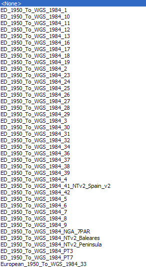
As stated in part one, often, there will be a choice of coordinate transformations to select from, some more suitable than others depending upon factors such as accuracy, derivation and region of use. The latter concern is particularly important. The screenshot below shows there are many coordinate transformation options from GCS_WGS_1984 to GCS_European_1950, however only a certain number are valid, eg in the North Sea some options are valid only in certain areas of use, such as Germany Offshore or Netherlands Offshore.

The obvious question is how can the user select from the many transformation options when they do not know which are fit for purpose? Fortunately, many companies have geodetic expertise and standards to assist users make a selection. Failing that, the EPSG Geodetic Parameter Dataset is an excellent resource for researching valid coordinate transformations.
Also note, although coordinate transformation names would seem to indicate transformation direction is from European Datum 1950 to WGS 1984, in this case the coordinate transformation is reversible and ArcMap handles the direction automatically.

Change
The world is forever changing and this is also true for coordinate transformations, whether it is literally – in the case of a large earthquake – or simply if a company begins exploring in a frontier region that has ill-defined or aging geodetic standards. New coordinate transformations are always being derived and old ones deprecated. ArcGIS lists both valid and deprecated coordinate transformations so as to maintain backwards compatibility when using older geographic data but proceed with care – it gives no indication of whether a particular coordinate transformation has been deprecated or not!
Summary
- In ArcGIS, the onus is on the user to understand their data, CRSs and coordinate operations for the regions in which they are working.
- Users should not ignore or dismiss ArcGIS Warning dialogs – they are there for a reason!
- Users should never click the ‘Don’t warn me again…’ checkboxes. If they have done so in the past, uncheck the Skip Datum Check setting in the ArcMap Advanced Settings Utility to ensure coordinate transformation warning dialogs display when necessary.
- To ensure correct alignment of features in the map, users should make sure that a valid coordinate transformation is set in the data frame for each map layer whose CRS property is based on a different geodetic datum to that of the data frame.
- Finally, this can be a very tricky and complex problem with potentially important impacts so, if in doubt, do seek expert assistance!
Posted by Ian Milligan, Senior Consultant, Exprodat.


