Exprodat carried out its second industry benchmark survey in 2014, measuring geospatial capability maturity across 18 oil & gas operators worldwide (including Independents, IOCs and NOCs). Initial results were presented at the European PUG conference in November, and we are now pleased to make the full report available free of charge.
From GIS resourcing levels to data quality, from training spend to emerging standards cases, this report offers unique insights and analysis on the current state of GIS in the E&P industry.
Read the high-level summary below, or download the full 25-page report.
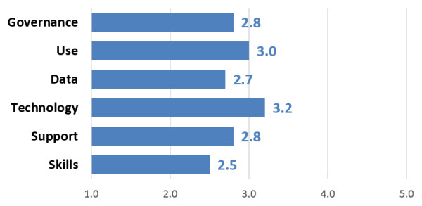
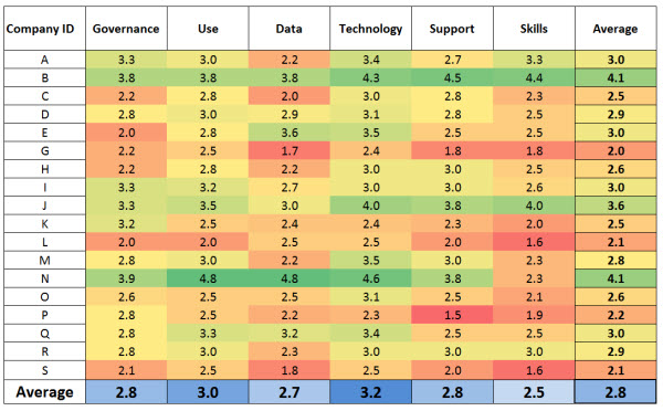
Every company who took part in this survey filled in an extensive questionnaire based on the GIS Maturity Matrix. The responses were then scored on a scale of 1 to 5, covering six discrete areas across the spectrum of geospatial capabilities: Governance, Usage, Data, Technology, Support and Skills. The survey also collected financial data relating to spending on GIS software, training, data, support, staffing and IT.
Summary of results
The industry’s average score is 2.8 out 5, leaving much room for improvement although there are some encouraging signs that things are beginning to move in the right direction. Still, the overall score is virtually the same as in 2012, suggesting that the industry is struggling to overcome some endemic issues and needs to embrace some fresh thinking and more radical strategies.

Unsurprisingly, technology came out as the most mature area. But the whole industry still struggles with data integration (quoted as the no. 1 support issue), and this is likely to hold back new breakthroughs such as data analytics.
In most companies there are also significant weaknesses in governance, project data, support, and – most disappointingly – skills and career development, which is bound to impact negatively on all other areas as well.
The spending figures also confirmed that, from the total cost of ownership of a GIS operation, technology is by far the cheapest element. Our industry loves talking about technology, but in doing so we risk neglecting much more important (and expensive) investments such as people or data.
However, there were also some highlights. Two companies achieved a score above 4, the highest band in a very demanding maturity model. One of these was later audited by Exprodat (at the company’s request), confirming the result. This is a remarkable achievement and shows what can be done with the right governance, strategy and skills.

This benchmark survey also showed that GIS is now seen as a core application in the E&P business. The potential of GIS as a game changer is understood by many, and its uses of GIS are also becoming more varied and advanced.
But to enable transformational change a new approach is required, and companies wanting to progress must review their geospatial strategies and priorities.
Full Report
To find out more about how the E&P industry is doing in terms of geospatial Governance, Usage, Data, Technology, Support and Skills, just click on the link below and follow the download instructions.
Posted by Thierry Gregorius, Principal Strategic Consultant, Exprodat.


