The second in our series of Petroleum GIS Tips where members of our training team explain how to perform a common E&P task or petroleum GIS workflow using ArcGIS Desktop. Its the sort of thing our technical consultants do a lot of when preparing data for our oil and gas clients, and this same workflow can apply to SQLServer Tables, Oracle, Access and even CSV files.
Loading Database Tables with XY Coordinates
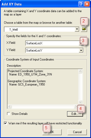
 Lets imagine that you’ve been provided with a database of wells for use in a data room and you’d like to import the locations in to ArcGIS Desktop in order to compare their locations with the data in your own company’s GIS ‘Wells’ layer. The database has a well header table and luckily this includes fields for X and Y location. Fortunately the fields are formatted as the numeric data type – if they weren’t you’d have to convert them from text into numeric, but that’s for another day. To load the data in to ArcGIS Desktop you’ll need to follow this workflow:
- Open the Add XY Data Tool by selecting ‘Tools > Add XY Data’ from the ArcMap menu.
- Navigate to and select your database and table.
- Select the table fields that have the X and Y (or Latitude and Longitude) coordinates.
- Select the coordinate system that the wells are in.
- Click OK.
- A dynamic ‘Events’ layer will then be added to the table of contents.
- You can then export this data to a shapefile or other feature class by right clicking on the file in the table of contents and select ‘Data > Export Data’.
Posted by Chris Jepps, Technical Director, Exprodat.


