In my last post (part 1), I described two scenarios when ArcMap undertakes coordinate operations, commonly known as “on-the-fly projection”. In the second scenario, the user must select a valid coordinate transformation to ensure map layers are correctly aligned.
In this post, I will outline how ArcMap informs the user a coordinate transformation is required and discuss some pitfalls.
ArcMap Warning Dialogs
There are potential issues due to the way ArcGIS displays warning dialogs, the sometimes counter-intuitiveness of the user interface for selecting coordinate transformations and the fact ArcGIS does not strictly enforce coordinate transformation integrity.
1. Adding a New Map Layer
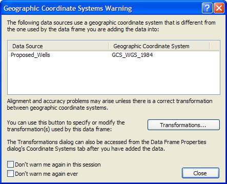
When adding a new map layer that has a CRS property based on a different geodetic datum to that of the data frame, the Geographic Coordinate Systems Warning dialog opens. This warns that one or more coordinate transformations should be selected by the user to achieve correct alignment on the map. It also displays a list of map layers which require transforming and their CRS properties:

Without strict enforcement of coordinate transformation integrity, the temptation for the end user is to click Close, plough on regardless and ignore alignment errors altogether, resulting in potentially mis-aligned layers within the map.
2. Changing the CRS Property of the ArcMap Data Frame
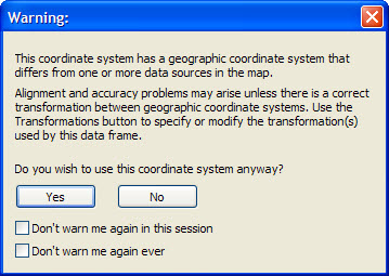
A different warning dialog opens when changing the CRS property of the data frame to a CRS based on a different geodetic datum to that used by one or more map layers:

Again, the temptation for the end user is to ignore the warning and plough on regardless.
Pitfalls – The ‘Don’t Warn me’ Checkboxes
Furthermore, both dialogs have two checkboxes that prevent warning dialogs from opening again during the current ArcMap session or – most alarmingly – ever again! There is a very real danger of users ticking one or both and, in all likelihood, thereafter creating maps containing positional errors.

You may ask, “Why doesn’t ArcGIS just enforce integrity?”. Well, many ArcGIS customers will, quite simply, not be concerned about this, whether it be because they work in a common CRS (eg local government in England work only with the British National Grid) or only undertake regional mapping. For this reason, Esri provide a mechanism to ignore potential coordinate transformation integrity issues.
However, the oil and gas industry frequently requires spatial analysis and mapping with a high degree of precision and positional accuracy. The possibility that warnings of potential coordinate transformation integrity issues have been disabled is a significant issue.
In my final post (part 3), I will explain how to set coordinate transformations in ArcGIS.
Posted by Ian Milligan, Senior Consultant, Exprodat.


