As mentioned in a previous blog, ArcMap can correctly align layers of geographic data with different spatial reference (also called ‘coordinate reference system’ or ‘CRS’) properties within the same data frame. This so-called “on-the-fly projection” leaves source data unchanged – it does not permanently change it in any way whatsoever.
Using this functionality, companies avoid retaining multiple copies of the same geographic data with different CRS properties and this is a key benefit of using GIS software to manage and visualise geographic data.
However, inexperienced end users who are unaware how ArcMap undertakes on-the-fly projection coordinate operations may, quite reasonably, assume it will automatically align map layers in the data frame but this is not always true.
There are two primary use cases to consider:
- Case one – map contains geographic data based on the same geodetic datum
- Case two – map contains geographic data based on different geodetic datums
Case one – data based on the same geodetic datum
In this first case, the data frame and/or one or more map layers contained within it have different CRS properties that are based on the same geodetic datum. ArcMap needs only undertake coordinate conversions (often referred to a “projecting” or “un-projecting” the data) to correctly align features in different map layers.
Coordinate conversions are based on relatively accurate, unambiguous mathematical rules which ArcMap follows to convert geographic data in the data frame with relatively high accuracy.
Providing the required coordinate conversions are supported within ArcGIS (and most, but not all, are supported – see the ArcGIS Desktop Help for a comprehensive listing), ArcMap will automatically undertake the conversions and correct alignment is achieved.
So, in this case, ArcMap will handle the coordinate conversion automatically.
Case two – data based on different geodetic datums
In this second case, the data frame and/or one or more map layers contained within it have CRS properties that are based on different geodetic datums. ArcMap must undertake coordinate transformations (sometimes referred to as “datum transformations”) – possibly in addition to coordinate conversions – to correctly align features in different map layers.
Coordinate transformations are derived empirically using a set of common locations on different geodetic datums and therefore the choice, allocation, quality and number of points used can affect their accuracy.
In ArcGIS, the user must select the most suitable coordinate transformations (one transformation per map layer to be transformed) for correct alignment to be achieved in ArcMap. Often, there is a choice of coordinate transformations to select from, some more suitable than others depending upon their accuracy, derivation, region of use and fitness for purpose.
So, in this case, the onus is on the user to select a suitable coordinate transformation.
Potential Errors
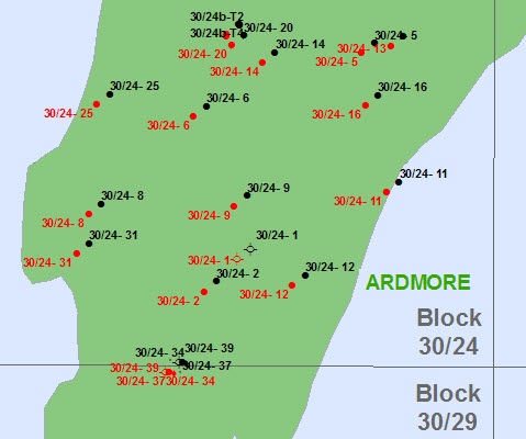
So, why is this so important? Let’s consider a real world example of wells in the central North Sea. The CRS property of the data frame is ED50/UTM Zone 31N and a coordinate transformation has not been set.

The CRS property of the black wells is European Datum 1950 (GCS_European_1950 in ArcGIS, commonly referred to by the alias ‘ED50’) and they are correctly aligned. They have been converted automatically to ED50/UTM Zone 31N by ArcMap because only a coordinate conversion is required (see case one above).
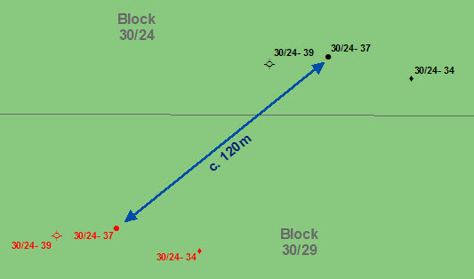
The CRS property of the red wells is WGS 1984 (GCS_WGS_1984 in ArcGIS) and they are incorrectly aligned. They have not been transformed to ED50/UTM Zone 31N because the coordinate transformation has not been set in the data frame by the user.
Interestingly, the mis-alignment has positioned wells 30/24-34, 30/24-37 and 30/24-39 over the southern block boundary into block 30/29.

In part 2, I will explain when coordinate transformations should be set and some things to watch out for when doing this in ArcGIS.
Posted by Ian Milligan, Senior Consultant, Exprodat.


